


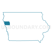
PIERSON Voting District, Woodbury County, Iowa
About
Outline

Summary
| Unique Area Identifier | 583788 |
| Name | PIERSON Voting District |
| County | Woodbury County |
| State | Iowa |
| Area (square miles) | 0.62 |
| Land Area (square miles) | 0.62 |
| Water Area (square miles) | 0.00 |
| % of Land Area | 100.00 |
| % of Water Area | 0.00 |
| Latitude of the Internal Point | 42.54280250 |
| Longtitude of the Internal Point | -95.86527620 |
Maps


Graphs
Select a template below for downloading or customizing gragh for PIERSON Voting District, Woodbury County, Iowa


Neighbors
Neighoring Voting District (by Name) Neighboring Voting District on the Map
- RUTLAND TWP W/O PIERSON Voting District, Woodbury County, IA
- UNION TWP W/O CORRECTIONVILLE & PIERSON Voting District, Woodbury County, IA